Monterrey
Ciudad Victoria
Baton Rouge
Louisiana
Austin
Texas
Caribbean Sea
Kingston
Port-au-Prince
Holguín
Cockburn Town
Dominican Republic
Lesser Antilles
Bridgetown
Roseau
St. John's
Road Town
Cancún
Mérida
Honduras
Belmopan
Bilwi
Nicaragua
Managua
George Town
Cuba
Guatemala
Guatemala City
Acapulco
Tuxtla Gutiérrez
Mexico City
Guadalajara
Bahamas
Nassau
Gulf of Mexico
Havana
Miami
Florida
Tallahassee
Odessa
Hermosillo
Chihuahua City
Fresnillo
La Paz
Culiacán
Mexico
Ciudad Juárez
Richmond
Washington
Harrisburg
New York
Raleigh
North Carolina
Frankfort
Charleston
Columbus
Atlanta
Columbia
Nashville
Indianapolis
Springfield
Mississippi
Illinois
Virginia
Ohio
Kentucky
Tennessee
Indiana
Alabama
Georgia
Montgomery
Jefferson City
Little Rock
Jackson
Arkansas
Oklahoma
Missouri
Kansas
Dallas
Oklahoma City
Topeka
United States
Lincoln
Phoenix
Arizona
Moab
Gallup
New Mexico
Santa Fe
Colorado
Denver
Utah
Salt Lake City
Lamar
Lubbock
Maine
Quebec
Montpelier
Albany
Ottawa
Saguenay
Matane
Lake Ontario
Augusta
Boston
New York
Pennsylvania
Halifax
Nova Scotia
Fredericton
Charlottetown
Newfoundland
Gulf of Saint Lawrence
New Brunswick
Iowa
Minnesota
Saint Paul
Des Moines
Nebraska
Pierre
South Dakota
Bismarck
North Dakota
Hibbing
Fargo
Cheyenne
Wyoming
Pocatello
Rapid City
Havre
Billings
Montana
Helena
Hamilton
Toronto
Lake Erie
Lake Superior
Lake Huron
Lake Michigan
Wisconsin
Michigan
Lansing
Madison
Thunder Bay
Marquette
Sudbury
Rouyn-Noranda
© OpenStreetMap contributors
Sunday 24
  • 03
  • 06
  • 09
  • 12
  • 03
  • 06
  • 09
Monday 25
  • 03
  • 06
  • 09
  • 12
  • 03
  • 06
  • 09
Tuesday 26
  • 03
  • 06
  • 09
  • 12
  • 03
  • 06
  • 09
Wednesday 27
  • 03
  • 06
  • 09
  • 12
  • 03
  • 06
  • 09
Thursday 28
  • 03
  • 06
  • 09
  • 12
  • 03
  • 06
  • 09
Friday 29
  • 03
  • 06
  • 09
  • 12
  • 03
  • 06
  • 09
Saturday 30
  • 03
  • 06
  • 09
  • 12
  • 03
  • 06
  • 09
Sunday 31
  • 03
  • 06
  • 09
  • 12
  • 03
  • 06
  • 09
Monday 1
  • 03
  • 06
  • 09
  • 12
  • 03
  • 06
  • 09
Tuesday 2
  • 03
  • 06
  • 09
  • 12
  • 03
  • 06
  • 09
Wednesday 3
  • 03
  • 06
  • 09
  • 12
  • 03
  • 06
  • 09
Thursday 4
  • 03
  • 06
  • 09
  • 12
  • 03
  • 06
  • 09
Friday 5
  • 03
  • 06
  • 09
  • 12
  • 03
  • 06
  • 09
Saturday 6
  • 03
  • 06
  • 09
  • 12
  • 03
  • 06
  • 09
Sunday 7
  • 03
  • 06
  • 09
  • 12
  • 03
  • 06
  • 09
3 PM
Go Premium
kt051020304060
Developed with
Download App
NASA Finds Wind Shear Affecting Tropical Cyclone Uesi
-
2291 days ago
2
...

NASA satellite imagery revealed that vertical wind shear appears to be affecting Tropical Cyclone Uesi in the Southern Pacific Ocean.

On Feb. 13 at 0315 UTC (Feb. 12 at 10:15 p.m. EST), the MODIS instrument that flies aboard NASA’s Aqua satellite provided a visible image of Tropical Cyclone Uesi being adversely affected by vertical wind shear.

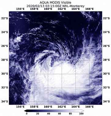
On Feb. 13 at 0315 UTC (Feb. 12 at 10:15 p.m. EST), the Moderate Resolution Imaging Spectroradiometer or MODIS instrument that flies aboard NASA’s Aqua satellite provided a visible image of Tropical Cyclone Uesi being adversely affected by vertical wind shear. The image showed that the bulk of clouds were being pushed to the southeast of the center of circulation.

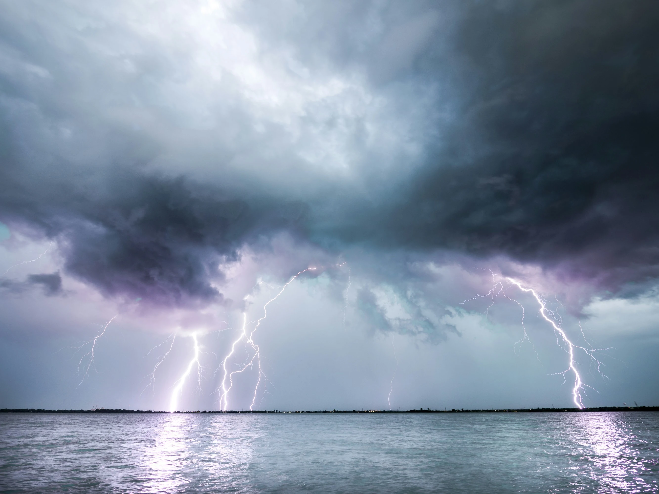
In general, wind shear is a measure of how the speed and direction of winds change with altitude. Tropical cyclones are like rotating cylinders of winds. Each level needs to be stacked on top each other vertically in order for the storm to maintain strength or intensify. Wind shear occurs when winds at different levels of the atmosphere push against the rotating cylinder of winds, weakening the rotation by pushing it apart at different levels. Northwesterly wind shear was affecting Uesi and pushing the bulk of clouds to the southeast of the center.

At 0300 UTC on Feb. 13 (10 p.m. EST on Feb. 12), the Joint Typhoon Warning Center (JTWC) issued the final bulletin on Tropical cyclone Uesi. At that time, Uesi was located near latitude 27.7 degrees south and longitude 161.1 degrees east, about 332 nautical miles southwest of Noumea, New Caledonia. Uesi had maximum sustained winds near 55 knots (63 mph/102 kph). The storm was moving to the south-southwest.

On Feb. 13 at 11:59 pm AEDT (Australia Eastern Time) or 7:59 a.m. EST, the Australian Bureau of Meteorology (ABM) noted “Ex-tropical cyclone Uesi is moving rapidly southwards and will produce destructive wind gusts at Lord Howe Island over the next few hours.” ABM said that the system is expected to maintain an intensity equivalent to a category 2 tropical cyclone as it passes the island. For updates from ABM, visit: http://www.bom.gov.au/.

NASA’s Aqua satellite is one in a fleet of NASA satellites that provide data for hurricane research.

Tropical cyclones/hurricanes are the most powerful weather events on Earth. NASA’s expertise in space and scientific exploration contributes to essential services provided to the American people by other federal agencies, such as hurricane weather forecasting.

Rob Gutro
NASA’s Goddard Space Flight Center

https://www.windy.com/-Satellite-satellite?satellite,-21.600,153.911,5,internal

Related content

2 claps

Comments (0)

Thermals: the invisible engine of unpowered flight
Jari Sochorová
-
updated 3 days ago
What's New in v50: Read the Avalanche Bulletins, Trace the Wind, Plan the Passage
Nicole Dolezalova
-
updated 6 days ago
Holiday Update: New Tools for Winter Weather and Ocean Forecasts, Meet Version 48
-
updated 5 days ago
Winter Weather: From Snowflakes to Extreme Snowfall
-
updated 13 days ago
What's New in v49: Faster, Smarter and made to Fly
-
updated 18 days ago
Windy Gets Smarter with Speed Vector and iOS Webcam Widgets
Nicole Dolezalova
-
updated 37 days ago
Spring in the Air: How CAMS Pollen Forecasts Are Made
-
updated 53 days ago
Earth Day with Windy: Understanding the Power of Our Planet
-
updated 55 days ago
From Storm Alerts to Forecasts on Your Garmin: Windy’s Biggest Update Yet
-
updated 88 days ago
Sneak Peek into Windy v47: Smarter, Cleaner & More Connected
-
updated 88 days ago