In mid-January, the far south of Russia’s Kamchatka Peninsula was affected by a series of deep cyclones. The associated winter storms produced exceptional snowfall. In Petropavlovsk-Kamchatsky, 131.6 mm (≈ 5.2 in) of precipitation was recorded from 13–16 January 2026 (120% of the monthly normal), with snow depth at the meteorological station reaching 170 cm (≈ 67 in). According to available records, this was the city’s highest snow depth in 55 years.
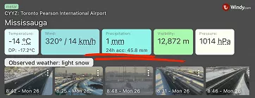
In Canada’s largest city, Toronto, Toronto Pearson International Airport recorded a daily total of 46 cm (≈ 18.1 in) of fresh snow on Sunday, 25 January, setting a new one-day snowfall record. Observations at the airport date back to 1938.
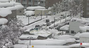
Even parts of northwestern and western Japan have experienced record-breaking snowfall this winter. Above-average snow depths are the result of frequent January snowfall, which affected Hokkaido in particular and the western part of Honshu.
In Sapporo, Hokkaido, snow depth reached 110 cm (≈ 43.3 in) on 26 January. The last time it exceeded the one-metre mark was in January 2005, 21 years ago.
In Aomori City, in northern Honshu, snow depth reached 183 cm on Sunday, 1 February 2026. According to the Japan Meteorological Agency, this is the highest value in the past 40 years and the first time since 1986 that snow depth has exceeded 180 cm (≈ 70.9 in). The all-time record in Aomori is 209 cm, observed on 21 February 1945; records at this site date back to 1893.
Extreme snowfall in these regions was linked to winter storms during frigid Arctic air outbreaks. In addition to synoptic-scale mechanisms such as low-pressure systems, local and regional processes also played an important role in further enhancing snowfall totals.
In this article, we examine the processes that determine how much snow from a cloud actually reaches the ground and highlight selected historical episodes of extreme snow accumulation. Loosely building on the article Winter Weather: From Water Vapour to Unique Snowflake, we shift from snowflake formation to the conditions that allow snow to accumulate at the surface.
Typical Synoptic Setups for Snowfall
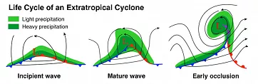
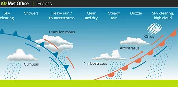
Snowfall most often occurs during synoptic setups that typically produce precipitation. If the atmosphere is sufficiently cold and temperatures remain below 0 °C (32 °F) throughout the entire vertical profile from the cloud layer down to the surface, precipitation will fall predominantly as snow. This includes various parts of low-pressure systems, from frontal boundaries (warm fronts, cold fronts, and occlusions) to the broad precipitation shields of cyclones, such as wrap-around/deformation zones (e.g., the comma head).
In addition, some situations can trigger snowfall or enhance it locally, such as industrial snowfall, orographic snowfall, and lake-/sea-effect snow.
Industrial Snowfall (Anthropogenic Snow)
Industrial snowfall most often occurs at low temperatures (often around −5 °C, 23 °F), under calm or light winds, with low clouds or fog, and with a high concentration of both condensation nuclei and ice nuclei.
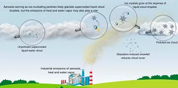
The low cloud layer typically has a base near the ground (below ~150 m, ≈ 500 ft) and a thickness of about 200–300 m (≈ 650–1,000 ft); higher-level clouds are often absent above it. Nocturnal radiative cooling of the upper part of the cloud/fog layer promotes mixing and the formation of supercooled droplets. Additional aerosols, moisture, and waste heat from industrial sources can further enhance mixing, accelerate ice particle growth, and trigger light snowfall, most often just before sunrise.
Usually, only a thin layer of snow falls, often less than 2 cm (≈ 0.8 in), but documented cases exist, for example, in West Virginia, USA (near the John E. Amos power plant, December 1975) or in the Texas Panhandle, USA (February 2014), where around 10 cm (≈ 4 in) of snow accumulated overnight.
Orographic Snowfall
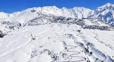
Orographic snowfall occurs in mountainous terrain when moist air is forced to rise along the windward side of a mountain range. As the air ascends, it cools, condenses, and forms clouds, from which snow can fall when the atmospheric column is sufficiently cold. The key factor here is not atmospheric instability, but the mechanical forcing of upward motion as airflow passes over the terrain.
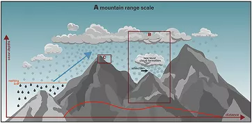
A pronounced spatial variability is typical: tens of centimeters of snow (several inches to over a foot) can fall in a short time on windward slopes, while on the leeward side, where air descends and dries out, a so-called snow shadow forms with much lower totals, sometimes with no precipitation at all.
Another characteristic is persistence: under steady airflow and with sufficient moisture, snowfall can continue for hours or even days, often leading to very high accumulations in mountainous areas.
Orographic snowfall is therefore responsible for the highest long-term snowfall totals in many mountainous regions worldwide, including the Alps, the Rocky Mountains, the Cascade Range, the Canadian Coast Mountains, the Japanese Alps, and New Zealand’s mountain ranges. Rapid snowpack buildup during persistent orographic snowfall also directly affects avalanche danger and hydrological conditions in mountain watersheds.
Orographic snowfall can also enhance precipitation that is already present. It can significantly intensify snowfall along fronts or amplify lake-effect snow in areas where snow bands encounter mountainous terrain.
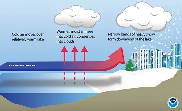
Lake-Effect Snow in the Great Lakes Region
In the North American Great Lakes region, lake-effect snowfall can develop as heat and moisture from the lake surface are transferred into the atmosphere. It occurs when very cold Arctic air flows over the relatively warm water, warming and moistening as it passes over the lakes.
A commonly used rule of thumb is that for lake-effect snow to develop, the temperature difference between the lake surface and the air at about 1.5 km altitude (≈ 1 mi, ≈ 850 hPa) should reach at least 13 °C (23 °F). This promotes instability and the formation of cumulus (Cu) and stratocumulus (Sc) clouds, and in more extreme cases, even cumulus congestus (Cu con) and locally cumulonimbus (Cb).
Wind direction is also important because it determines the length of the airflow path over open water (fetch). The longer the fetch, the more heat and moisture the air can pick up from the lake. To produce long snow bands and “cloud streets,” a fetch of at least about 100 km (≈ 60 mi) is usually needed, although the exact value depends on the temperature contrast between the water and the air, atmospheric instability, and wind shear.
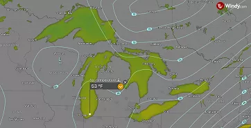
Lake-effect snow on radar: precipitation bands over Lake Michigan affecting the Chicago–South Bend area (10 Nov 2025).; Windy.com
A typical feature of these bands is pronounced spatial variability. They are often very narrow (only a few kilometers wide), so while more than 75 cm (≈ 30 inches) of snow may fall in one area, only a few centimeters may accumulate just a few kilometers away.
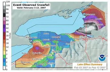
One of the most remarkable multi-day episodes occurred from 3 to 12 February 2007 across the Tug Hill Plateau near Redfield, New York, when up to 141 inches (≈ 358 cm) of snow fell over 10 days.
The largest reported 24-hour lake-effect total is often cited as 77 inches (≈ 196 cm) in Montague, New York, during 11–12 January 1997; however, because standard measurement procedures were not followed, this value was not accepted by an NWS review committee as an official 24-hour record.
Lake/Sea/Ocean-Effect Snowfall
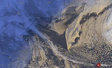
Lake-effect snow is not limited to the Great Lakes region, but can occur wherever very cold air flows over a sufficiently large, relatively warm body of water and then moves onshore. When the water body is a sea or an ocean, the same mechanism is referred to as sea-effect or ocean-effect snow. A classic example is Japan’s Sea of Japan coast, where the winter northwesterly monsoon produces heavy snowfall, often further enhanced by orographic lifting. Similar conditions occur, for instance, around the Black Sea (especially in northern Turkey, including Istanbul) and around the Caspian Sea, particularly along the southwestern coast of northern Iran.
Sea-effect snowfall over Japan (25 January 2026); Windy.com
Blizzards Are Formed by a Combination of Strong Winds and Snow
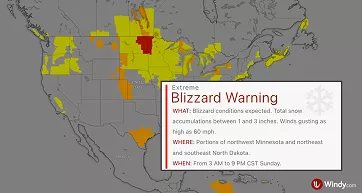
Snow plays a major role in a blizzard, but it does not necessarily have to be snowing during the event. The U.S. National Weather Service (NWS) defines a blizzard as a situation in which sustained winds or frequent gusts reach at least ~35 mph (≈ 56 km/h), and significant falling and/or blowing snow occurs, often reducing visibility to 1/4 mile (≈ 400 m) or less for at least 3 hours.
A blizzard is typically associated with a deep low-pressure system (an intense winter storm), with the worst conditions often occurring in its rear sector and in the wrap-around/deformation zone (the comma head), where strong winds combine with snowfall. Another common scenario occurs behind a strong cold front, with gusty winds and snow showers. Hazardous conditions can also develop during a ground blizzard, when dry, powdery snow is lofted and blown around between a departing low and a strengthening high-pressure system.
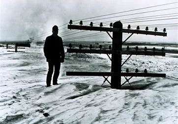
During a blizzard, the main hazard is a rapid drop in visibility, sometimes to whiteout conditions, when falling and blowing snow makes it difficult to maintain orientation even over short distances. Strong winds quickly redistribute snow and create drifts, so even with relatively small new snowfall totals, roads can become impassable, vehicles can get stranded, and some areas may become isolated. The wind also greatly increases heat loss from the body (wind chill), raising the risk of hypothermia and frostbite.
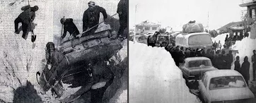
The early February 1972 blizzard in Iran (3–9 February) is often cited as one of the worst and, in some accounts, among the deadliest in modern history. Over the course of about a week, the country was hit by a series of exceptionally intense snowstorms accompanied by severe cold. In some areas, snowfall totals reached several metres, and snowdrifts in the south were estimated at up to 7.9 m (≈26 ft). The town of Ardakan and nearby villages were among the hardest hit, with no survivors reported in Kakkan and Kumar. During the cold spell, temperatures in some areas dropped to −25 °C (−13 °F). Estimates suggest the disaster claimed around 4,000 lives.
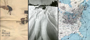
In the United States, one of the most destructive blizzards was the Great Blizzard of January 1978, which occurred from 24 to 28 January. An exceptionally deep cyclone hit mainly the Ohio Valley and the Great Lakes region: its central pressure dropped to 955.5 hPa, and wind gusts in Cleveland reached 82 mph (132 km/h). The storm brought intense snowfall, massive snowdrifts, and widespread whiteout conditions. It claimed around 90 lives and caused an estimated $100 million in damage (in 1978 dollars).
One last interesting fact: Yuki-no-Otani
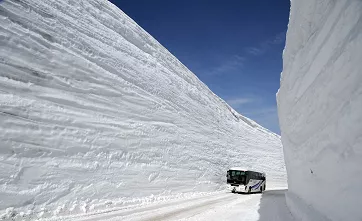
Yuki-no-Otani is a snow corridor along the Tateyama Kurobe Alpine Route, a mountain route across the Northern Japanese Alps that is world-famous for its giant snow walls. In the Tateyama massif, especially near the highest point of the route at Murodo (about 2,450 m (≈ 8,000 ft)), an exceptional amount of snow accumulates during winter. This is due to a combination of the winter northwesterly (monsoonal) flow, which brings moist air from the Sea of Japan, and strong orographic enhancement on the windward side of the Japanese Alps.
In winter, the route is closed due to the heavy snowfall and reopens in early spring, when heavy machinery must literally cut through the snow to create the corridor. In April 2025, the snow walls reached roughly 16 m (≈ 52 ft), while the historical maximum of around 20 m (≈ 66 ft) was recorded in 2000.
Snowfall and Snow Cover on Windy.com
Windy.com offers a wide range of features to help you monitor snowfall, estimate how precipitation will evolve over the next few hours, and assess how much snow may accumulate on the ground.
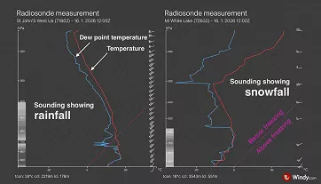
For an up-to-date picture of current conditions, use radar and satellite observations, weather-station measurements, radiosonde observations, and webcams, which give a direct view of what is happening on the ground.
For the forecast, Windy.com includes multiple model layers. The key layers for snow conditions are New snow (forecast snowfall accumulation over the selected time period) and Snow depth (forecast snow cover on the ground). In general, the most useful level of detail is obtained by using the highest-resolution model available for a given area.
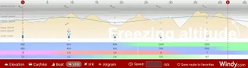
To estimate at what altitude snow may turn into rain, you can use the Freezing altitude information. It shows the approximate altitude of the highest freezing level (0 °C/32 °F) and can be viewed as a map layer, as isolines, or as a vertical cross-section along a selected route in VFR mode.


Comments (1)