Lesser Antilles
Bridgetown
Roseau
St. John's
Road Town
Cancún
Mérida
Honduras
Belmopan
Bilwi
Nicaragua
Managua
George Town
Cuba
Guatemala
Guatemala City
Acapulco
Tuxtla Gutiérrez
Mexico City
Guadalajara
Bahamas
Nassau
Hamilton
Gulf of Mexico
Havana
Miami
Florida
Tallahassee
Phoenix
Arizona
Moab
Gallup
New Mexico
Santa Fe
Colorado
Denver
Utah
Salt Lake City
Lamar
Lubbock
Monterrey
Ciudad Victoria
Baton Rouge
Louisiana
Austin
Texas
Odessa
Hermosillo
Chihuahua City
Fresnillo
La Paz
Culiacán
Mexico
Ciudad Juárez
Frankfort
Charleston
Columbus
Atlanta
Columbia
Nashville
Indianapolis
Springfield
Mississippi
Illinois
Virginia
Ohio
Kentucky
Tennessee
Indiana
Alabama
Georgia
Montgomery
Richmond
Washington
Harrisburg
New York
Raleigh
North Carolina
Jefferson City
Little Rock
Jackson
Arkansas
Oklahoma
Missouri
Kansas
Dallas
Oklahoma City
Topeka
United States
Lincoln
Toronto
Lake Erie
Lake Superior
Lake Huron
Lake Michigan
Wisconsin
Michigan
Lansing
Madison
Thunder Bay
Marquette
Sudbury
Rouyn-Noranda
Halifax
Nova Scotia
Fredericton
Charlottetown
Newfoundland
Gulf of Saint Lawrence
New Brunswick
Maine
Quebec
Montpelier
Albany
Ottawa
Saguenay
Matane
Lake Ontario
Augusta
Boston
New York
Pennsylvania
Iowa
Minnesota
Saint Paul
Des Moines
Nebraska
Pierre
South Dakota
Bismarck
North Dakota
Hibbing
Fargo
Cheyenne
Wyoming
Pocatello
Rapid City
Havre
Billings
Montana
Helena
Caribbean Sea
Kingston
Port-au-Prince
Holguín
Cockburn Town
Dominican Republic
© OpenStreetMap contributors
Sunday 17
  • 03
  • 06
  • 09
  • 12
  • 03
  • 06
  • 09
Monday 18
  • 03
  • 06
  • 09
  • 12
  • 03
  • 06
  • 09
Tuesday 19
  • 03
  • 06
  • 09
  • 12
  • 03
  • 06
  • 09
Wednesday 20
  • 03
  • 06
  • 09
  • 12
  • 03
  • 06
  • 09
Thursday 21
  • 03
  • 06
  • 09
  • 12
  • 03
  • 06
  • 09
Friday 22
  • 03
  • 06
  • 09
  • 12
  • 03
  • 06
  • 09
Saturday 23
  • 03
  • 06
  • 09
  • 12
  • 03
  • 06
  • 09
Sunday 24
  • 03
  • 06
  • 09
  • 12
  • 03
  • 06
  • 09
Monday 25
  • 03
  • 06
  • 09
  • 12
  • 03
  • 06
  • 09
Tuesday 26
  • 03
  • 06
  • 09
  • 12
  • 03
  • 06
  • 09
Wednesday 27
  • 03
  • 06
  • 09
  • 12
  • 03
  • 06
  • 09
Thursday 28
  • 03
  • 06
  • 09
  • 12
  • 03
  • 06
  • 09
Friday 29
  • 03
  • 06
  • 09
  • 12
  • 03
  • 06
  • 09
Saturday 30
  • 03
  • 06
  • 09
  • 12
  • 03
  • 06
  • 09
Sunday 31
  • 03
  • 06
  • 09
  • 12
  • 03
  • 06
  • 09
12 PM
Go Premium
kt051020304060
Developed with
Download App
How to Track Hurricane Rafael at Windy.com
extreme warning
How to Track Hurricane Rafael at Windy.com
-
updated 473 days ago
898
...

Real-time vs forecast

For the current situation regarding the hurricane, we recommend using the Radar+ layer. This combines satellite imagery and weather radar coverage if it's within the radar's reach. You can turn on/off the satellite or radar layer as you want.

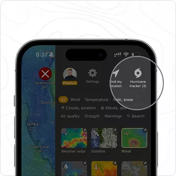
Where to find the Hurricane Tracker

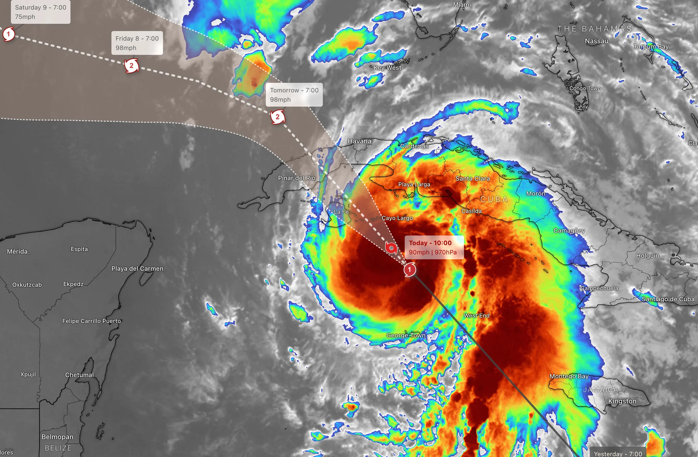
The ultimate tool for tracking hurricanes is the Hurricane Tracker, which has all available forecast scenarios. For the United States, these are usually issued by NHC, ECMWF, and UKM. By default, we always show the local model.

Using Windy images in media

Windyty, S.E. (owner of Windy.com) gives you full right to use any videos, animations, or screen captures in any media, project, or any other intellectual work for free as long as the "Windy.com" logo remains visible. If you want to go beyond screenshots or video captures, use Windy Embed at embed.windy.com

Windy Premium vs. Free

The Hurricane Tracker has no limitations. The hurricane forecast remains the same. We don't sell ads or data, and you don't even have to register. The Hurricane Tracker is free for all.

If you want to support us, we will happily have you as a Premium member. Subscribe to unlock a 15-day AI forecast, more frequent updates of the weather models, tide forecast, the route planner, a one-year archive of satellite and weather radar imagery, and much more.

HURRICANE WIND SPEEDS VS. FORECAST WIND SPEEDS EXPLAINED

As with every year during hurricane season, there is a lot of confusion about hurricanes, their forecast, and their measurements. That's why we've given you a brief summary of how to navigate Windy, where to find out about the current situation, and where to find forecast information.

Weather maps based on numerical models

All the weather maps you are used to on Windy are made up of numerical models that are created at a certain resolution (e.g. 9 km for the ECMWF model). They don't show the measured values, they show the forecast. Specifically, in the case of wind, it is the AVERAGE value at 10 meters above the ground. From such a map it is not possible to determine the maximum wind speeds of a hurricane.

Such maps show the direction of the tropical cyclone and the AVERAGE values, not maximum wind speeds. The model is created from data that is several hours old and is not used to describe the current situation.

That's why we developed a hurricane-tracking tool a few years ago.

The hurricane forecast using the Dvorak Technique

Some tropical cyclone observatories (NOAA, Met Office, ECMWF) also issue a special hurricane forecast, where they estimate the strength of the hurricane based on e.g. the Dvorak Technique, which also uses measurements directly from the hurricane for its calculations (measurement, and patterns usual for hurricanes in the area).

Hurricane data is collected, among other things, from aircraft flying directly into the hurricane. Much respect to all Hurricane Hunters!

LATEST UPDATES ON HURRICANE RAFAEL

Follow us on Twitter and other social media (Threads, Facebook, or Instagram) to get the latest updates.

898 claps

Comments (5)

Joshua
Joshua 578 days ago
lets get a update for the hurrcain tracker
mangaraw
mangaraw 584 days ago
@David-Polášek Every time I see new features being introduced, I get the sense that technology is genuinely advancing. It feels great to be living in the modern era.
idefix37
idefix37 584 days ago
@vegagb
You have already posted 2 messages stating that you never received a notification or email for an alert. The first one in 2021 and you never answered the questions intended to help you :
https://community.windy.com/topic/30716/no-alerts-ever?_=1728494572977
oopsi9943
oopsi9943 584 days ago
Happy they made it free for all.
Joshua
Joshua 585 days ago
hey this is great
Thermals: the invisible engine of unpowered flight
Jari Sochorová
-
updated 11 days ago
Winter Weather: From Snowflakes to Extreme Snowfall
-
updated 5 days ago
What's New in v49: Faster, Smarter and made to Fly
-
updated 10 days ago
Windy Gets Smarter with Speed Vector and iOS Webcam Widgets
Nicole Dolezalova
-
updated 30 days ago
Spring in the Air: How CAMS Pollen Forecasts Are Made
-
updated 46 days ago
Earth Day with Windy: Understanding the Power of Our Planet
-
updated 47 days ago
From Storm Alerts to Forecasts on Your Garmin: Windy’s Biggest Update Yet
-
updated 81 days ago
Sneak Peek into Windy v47: Smarter, Cleaner & More Connected
-
updated 81 days ago
Connect Windy with your Garmin Smartwatch. Weather Radar Included!
-
updated 81 days ago
Winter Weather: From Water Vapour to a Unique Snowflake
-
updated 97 days ago