The southwest monsoon, also known as the summer monsoon, has reached southern India, marking the official start of the rainy season. According to the India Meteorological Department (IMD), the monsoon arrived in the state of Kerala on May 24, 2025, which is eight days earlier than the usual onset date of June 1. This is the earliest onset in the past 16 years.
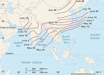
Average date of monsoon onset in Asia; Encyclopædia Britannica
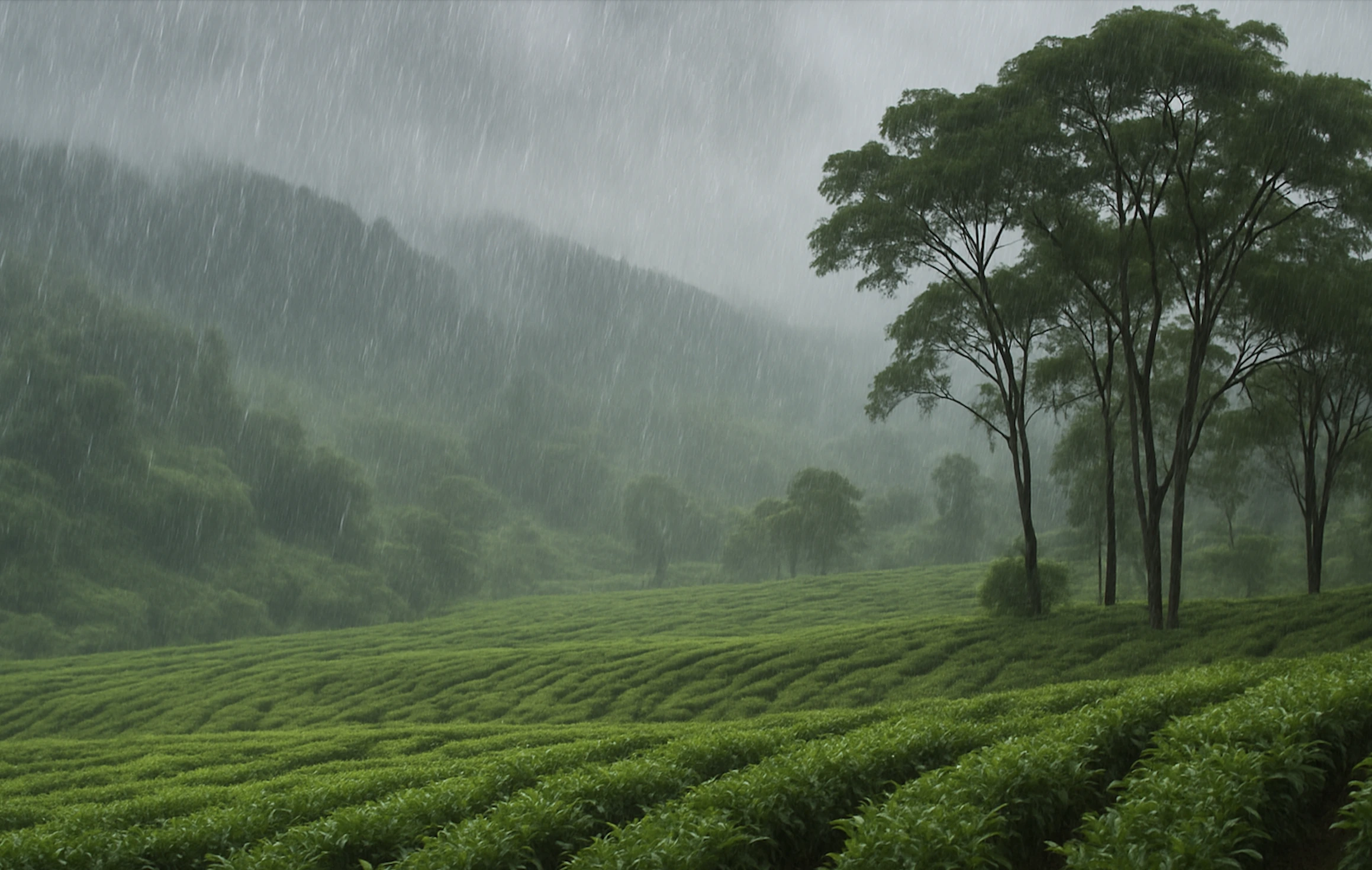
The summer monsoon follows a period of extreme heat and drought, bringing welcome relief in the form of cooler temperatures and, more importantly, life-sustaining rain essential for agriculture. However, the intense and persistent rains also come with risks: flash floods, widespread inundation, landslides, and damage to infrastructure.
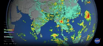
NASA’s visualization of precipitation and soil moisture over South and Southeast Asia on July 7, 2014; NASA's Goddard Space Flight Center
Typically, the monsoon season in India lasts from June 1 to the end of September. The monsoon usually covers the entire country by around July 8. During this period, India receives the majority of its annual rainfall.
In the coming days, monsoon rains will advance inland. They typically reach the capital city of Delhi between late June and early July, and around the same time, moist monsoon winds begin to affect the Himalayan foothills.
What Is a Monsoon?
A monsoon refers to a seasonal shift in wind patterns that occurs twice a year and significantly alters weather conditions, bringing either a rainy season or a dry season to the affected region.
The word monsoon originates from the Arabic word mausim, meaning "season" or "time of year."
The most well-known monsoons occur in South and Southeast Asia, but monsoon-like patterns are also found in other tropical and subtropical regions, such as West Africa, Australia, and parts of North and South America, as well as East Asia (e.g., China and Japan).
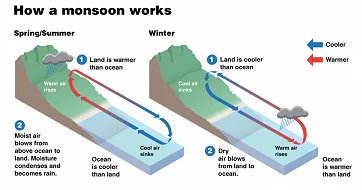
How seasonal heating differences between land and ocean trigger monsoon circulation; NOAA/JPL
What Causes the Monsoon?
The monsoon arises from differences in how land and ocean absorb heat. In spring and summer, land heats up faster than the surrounding ocean waters. Warm air over the land rises, creating a low-pressure zone. As air moves from high-pressure to low-pressure areas, moist air from the ocean is drawn inland. This inflow of moisture-laden air forms the summer monsoon.
When this moist air cools, it condenses into clouds and rain, leading to months of heavy rainfall. The heaviest precipitation typically occurs on the windward slopes of high mountains.
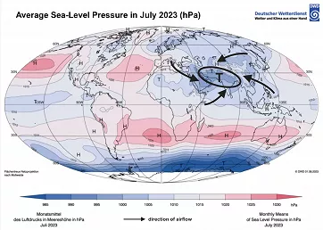
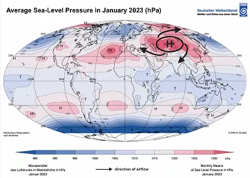
Global distribution of monthly mean and anomaly of sea-level pressure; DWD
In contrast, during the winter months, the land cools faster than the ocean, resulting in a high-pressure system over the continent. Cold, dry air then flows from the land toward the ocean. This winter monsoon brings dry weather to most of the region. However, in some island and coastal areas, this air may pick up moisture over the ocean and cause rain or snow.
How Much Rain Does India Receive During the Monsoon?
The average total rainfall across India during the southwest monsoon season (based on 1971–2020 data) is approximately 870 mm. However, there are significant regional differences:
- In northwestern and southeastern India, average rainfall for the season is less than 500 mm
- In contrast, some parts of the southwestern coast and the northeastern states often receive over 1500 mm
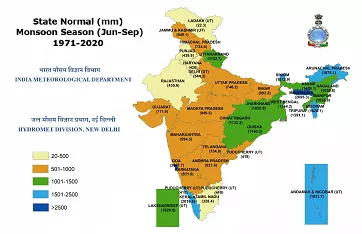
Average rainfall totals during the monsoon season (June to September); IMD
One of the most famous regions for extreme rainfall is Mawsynram and Cherrapunji in the Himalayan foothills of northeastern India. According to the World Meteorological Organization (WMO), Mawsynram holds the world record for the highest average annual rainfall, which is 11872 mm between 1941 and 1979, with most of that falling during the southwest monsoon.
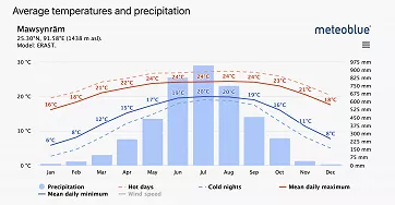
Average monthly temperature (°C) and precipitation (mm) in Mawsynram; meteoblue
When it comes to rainfall extremes, Cherrapunji holds the record for the highest annual rainfall ever recorded globally, with 26461 mm falling between August 8, 1860 and July 7, 1861.
2025 Monsoon Forecast
The India Meteorological Department (IMD) forecasts that the 2025 southwest monsoon season will bring above-average rainfall. Total rainfall for the season is expected to reach approximately 106% of the long-period average. During June to September 2025, most parts of the country are very likely to receive normal to above-normal rainfall, except for some regions in Northwest and East India, as well as many areas in Northeast India, where below-normal rainfall is expected.
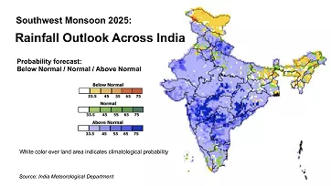
2025 Southwest Monsoon likely to be above normal (Long Range Forecast); IMD
This forecast is based on several key climate indicators, including sea surface temperatures in the equatorial Indian and Pacific Oceans, and associated phenomena such as the Indian Ocean Dipole (IOD) and the El Niño–Southern Oscillation (ENSO). The IMD also takes into account the extent of snow cover in the Northern Hemisphere, particularly over Eurasia.
The IOD is currently neutral, but a weak negative phase may develop during the southwest monsoon, potentially leading to reduced monsoon intensity and slightly lower rainfall in parts of India.
The ENSO is also neutral, but atmospheric patterns resemble La Niña, a phase that typically enhances monsoon rainfall. If this trend continues, it may slightly strengthen the monsoon.
Eurasian snow cover over the past three months has been below normal, a condition that tends to favor stronger summer monsoons in India.
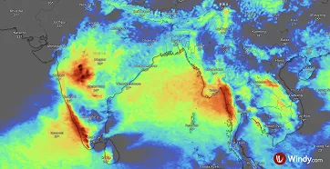
Illustrative image showing the Rain accumulation forecast layer on Windy.com; Windy.com
The monsoon brings both relief and challenges
Above-average rainfall can benefit crops and replenish water supplies, but it also carries the risk of heavy downpours and flooding.
With Windy.com, you can stay on top of both current and upcoming rainfall:
Radar+ shows where it’s raining right now, how intense the rain is, and even provides a very short-term forecast with rainfall interpolation for the next 60 minutes
The Rain, Thunder forecast layer displays expected rainfall for up to 15 days ahead, in 3-hour intervals (1-hour intervals for Premium users)
With the Rain Accumulation layer, you can easily see how much rain is forecast to fall over your selected time period


Comments (2)
Dr. Ibrar
Pakistan