September is the first meteorological month of autumn in the Northern Hemisphere. Days grow shorter and solar energy decreases, yet the oceans, thanks to their enormous heat capacity, still retain plenty of warmth. This provides enough energy for the formation and further development of tropical cyclones. Statistically, September is their peak period, and it often brings exceptionally powerful storms, such as Hurricane Dorian (2019) or Super Typhoon Mangkhut (2018).
September 4, 2019; NASA
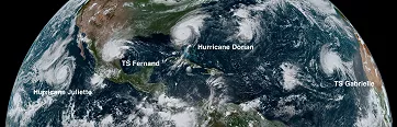
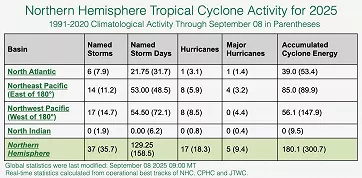
By September 8, 37 named storms had already formed in the Northern Hemisphere, slightly more than in an average year.
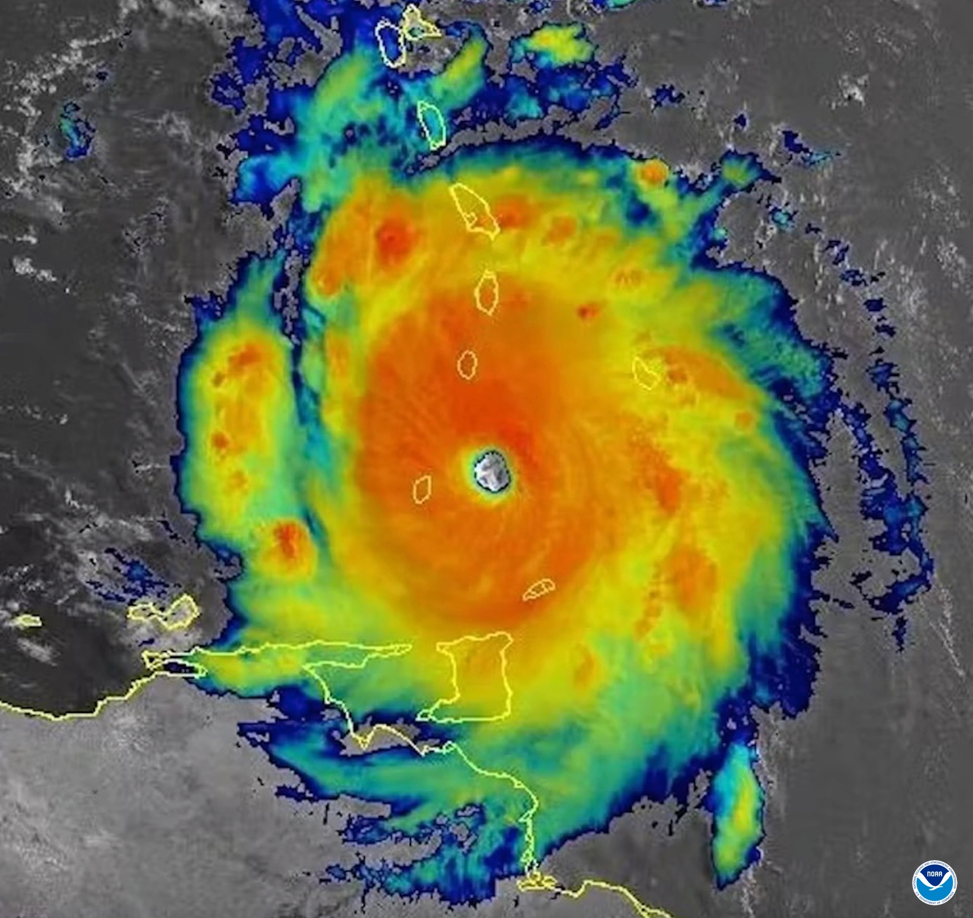
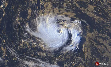
In the Atlantic, only six named storms developed, nearly two fewer than usual. The only major hurricane was Erin, which briefly reached Category 5 strength.
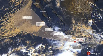
Hurricane Erin; Windy.com
In contrast, the Pacific has been busier. Fourteen storms formed in the eastern and central Pacific (about three more than average), eight became hurricanes, and four reached major hurricane status: Erick, Flossie, Kiko, and Iona. In the northwestern Pacific, 17 tropical cyclones developed, eight of which intensified into typhoons, including Danas, Co-May, Krosa, Podul, Kajiki, and Tapah. The North Indian Ocean has remained quiet, with no storms so far.
Northern hemisphere tropical cyclone activity 2025 (through September 8); Colorado State University
Meteorologists also track the Accumulated Cyclone Energy (ACE), which combines a storm’s strength (wind speed) and duration. In the Northern Hemisphere, it has so far reached only about 60% of the average, showing that although the number of storms is high, their overall intensity and lifespan remain below average. Overall, the season has been calmer than expected so far.
Why do devastating hurricanes sometimes form, while in other years the season remains unusually quiet? In the following text, we will look at the main conditions that determine the formation and development of tropical cyclones.
What is a tropical cyclone?
A tropical cyclone is a low-pressure system that develops in tropical regions over warm oceans. It appears as a destructive storm with a closed wind circulation around the center of low pressure.
Unlike mid-latitude lows, tropical cyclones are warm-core systems powered by latent heat released as water vapor condenses. Their warm core extends through the troposphere, giving them a symmetrical, vertically consistent structure that is not linked to fronts.
By contrast, mid-latitude cyclones are cold-core systems that typically form between 35° and 65° latitude. They draw their energy from horizontal temperature contrasts and are closely tied to cold, warm, and occluded fronts, which shape their development and weather patterns.
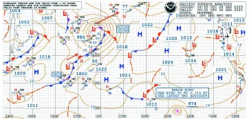
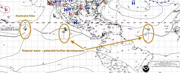
Extratropical lows and Tropical Cyclone Kiko (bottom right) on the NOAA Pacific Surface Analysis map; NOAA
The ingredients of tropical cyclone formation
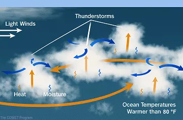
Tropical cyclones are complex systems that need a steady supply of heat and moisture. Cyclogenesis begins when a storm becomes self-sustaining, which requires deep convection and enough low-level rotation of air to support further growth.
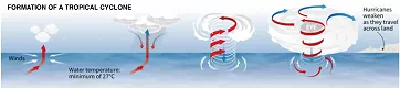
Formation of a tropical cyclone; Cléa PÉCULIER / Sophie RAMIS / AFP
For the development of deep convection, it is ideal when the sea surface temperature (SST) reaches at least 26.5 °C (about 80 °F) and warm water extends to a depth of at least 45 meters (about 150 feet). Warm ocean waters provide the necessary heat and moisture, which fuel tropical cyclones.
For air heated by the ocean surface to rise and form thunderstorm clouds, the atmosphere must cool sufficiently with increasing altitude. A moist mid-troposphere (at around 5 km) is also crucial, since excessively dry air at these levels can disrupt storm clouds and halt the development of circulation.
Thus, the development of deep convection requires:
sufficient oceanic thermal energy (SST > 26.5 °C to 45 m depth)
enhanced relative humidity in the mid-troposphere (700 hPa)
conditional atmospheric instability
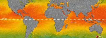
For tropical cyclones to form, sea surface temperatures (SST) must exceed 26.5 °C (80 °F). On the SST map, Tropical Storm Mario and Tropical Depression Blossom are marked; Windy.com
Air rotation (absolute vorticity) is influenced both by the actual swirling motion in the atmosphere (relative vorticity), for example due to the pressure field, and by the deflecting force of Earth’s rotation, the Coriolis force (planetary vorticity).
The Coriolis force is an apparent force that deflects motion to the right in the Northern Hemisphere and to the left in the Southern. Strongest at the poles and zero at the equator, it requires storms to form at least 500 km (300 miles, roughly 5° latitude) away for rotation to develop. As a result, hurricanes rotate counterclockwise in the Northern Hemisphere and clockwise in the Southern.
Wind shear refers to the change in wind direction and speed with height. In general, excessive shear (greater than 10–15 m/s (20-35 mph) between 850 and 200 hPa) can disrupt and weaken a tropical cyclone. In some exceptional cases, however, it may actually support storm development, though this is uncommon.
So, to sustain the rotation of a tropical cyclone, the following are required:
a position at least 5° latitude away from the equator
menhanced relative vorticity in the lower troposphere
generally weak vertical wind shear at the location of formation
Meeting these conditions is necessary for a tropical cyclone to form, but not sufficient. A tropical disturbance must first develop, and its transition to a closed circulation remains under study. Even under seemingly ideal conditions, disturbances may fail to intensify, making this stage one of the greatest challenges in modern meteorology.
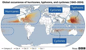
Areas of tropical cyclone occurrence and their regional names at ≥119 km/h (74 mph); BBC
Tropical disturbance
A tropical disturbance is an area of lower air pressure accompanied by extensive cloudiness and thunderstorm activity. The first signs of circulation may also appear, but a closed low-pressure center, characteristic of a tropical depression, has not yet formed.
Visualization of a tropical disturbance; UCAR
Tropical disturbances often form where conditions for thunderstorms align with initial atmospheric rotation. They most commonly develop in the monsoon trough, a low-pressure zone linked to seasonal monsoon flow. Unlike the Intertropical Convergence Zone (ITCZ), where trade winds converge with little rotation, the monsoon trough’s cyclonic flow makes vortex development more likely. The two are closely related, as the trough is essentially the monsoon-influenced part of the ITCZ.
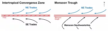
Intertropical Convergence Zone and Monsoon Trough: their depiction on synoptic analysis; WMO
A tropical wave (also called an easterly wave) is an atmospheric disturbance that moves westward with the trade winds. In the Atlantic, African tropical waves play a key role: they form over eastern Africa, travel westward across the ocean, and often act as seeds for tropical cyclones.
The positions of monsoon troughs, the ITCZ, and tropical waves are shown on the Tropical Surface Analysis maps produced by NOAA’s National Hurricane Center (NHC).
NOAA Tropical Surface Analysis; NOAA
Development of tropical cyclones
If conditions are favorable, a tropical wave can intensify into a depression, the weakest stage of a tropical cyclone, and then into a tropical storm. With further strengthening and sustained winds above 119 km/h (74 mph), it becomes a hurricane (Atlantic, northeastern/central Pacific), a typhoon (northwestern Pacific), or a cyclone (Indian Ocean and near Australia). Learn more in our article Hurricane, Tropical Storm, Typhoon or Just a Tropical Depression?.
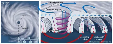
Infographic showing the structure of a tropical cyclone; Encyclopædia Britannica, Inc.
Under unfavorable conditions, cyclones weaken as convection fades, central pressure rises, winds slow, and the system may eventually dissipate.
What drives the movement of tropical cyclones
The movement of tropical cyclones over the oceans is the result of complex interactions with the surrounding atmospheric circulation.
In low latitudes (about 20–25°), trade winds on the equatorial side of the subtropical high steer them westward. This high is a semi-permanent area of high pressure near the Tropics of Cancer and Capricorn. At its western edge, tropical cyclones tend to curve, first poleward and then eastward, under the influence of the westerlies. These winds also govern the movement of extratropical cyclones in the mid-latitudes. Once tropical cyclones reach these latitudes, they gradually transform into extratropical lows.
Ex-tropical cyclones usually increase uncertainty in weather forecasts in the mid-latitudes, sometimes for several days ahead.
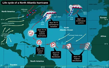
Life cycle of a North Atlantic hurricane; Encyclopædia Britannica, Inc.
Landfall
When a tropical cyclone strikes land, it quickly weakens as it loses its energy source, the warm and moist ocean. Dry continental air and friction further accelerate its decay. The rate depends on terrain: in mountainous areas like Haiti or the Philippines, circulation can collapse within hours, while over flatter regions such as Texas or India, systems may last one to three days.
Even after the circulation breaks down, a large amount of moisture remains in the atmosphere, often producing widespread rainfall. This can result in flooding hundreds of kilometers inland, and in mountainous terrain, dangerous landslides and mudflows.
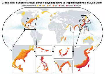
Global distribution of annual person-days exposure to tropical cyclones in 2002–2019; Jing, R., Heft-Neal, S., Chavas, D.R. et al. Global population profile of tropical cyclone exposure from 2002 to 2019. Nature 626, 549–554 (2024)
Large-scale circulation phenomena and their influence on the formation of tropical cyclones
The conditions for tropical cyclone formation, described earlier, are strongly influenced by seasonal and interseasonal circulation phenomena, including trade winds, subtropical highs, monsoons, tropical upper tropospheric troughs (TUTTs), and climate oscillations like El Niño–Southern Oscillation (ENSO) or Madden–Julian Oscillation (MJO).
The strength of the trade winds determines whether tropical waves can organize and how quickly they move across the ocean.
The position and intensity of the subtropical high govern not only the tracks of storms but also the conditions for their formation.
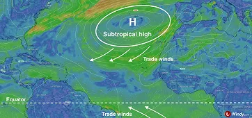
Schematic of trade winds and the subtropical high in the wind layer; Windy.com
Monsoon circulation in the Indian Ocean and surrounding regions plays a crucial role. During the peak of the southwest summer monsoon (June to September), fewer cyclones form, but at its beginning and end, conditions may be more favorable.
The monsoon gyre is a large cyclonic circulation in the western North Pacific, typical of the summer monsoon season. At about 850 hPa (1.5 km / 0.9 mi), it can span thousands of kilometers and last up to two weeks. Convection and rainfall concentrate along its southern to southeastern edge, where tropical storms and typhoons often form. Its development is linked to the breakdown of the monsoon trough and thunderstorm growth, though its direct role in cyclogenesis is unclear. Although rare, often only once a year, monsoon gyres can spawn entire sequences of tropical cyclones.
The Tropical Upper Tropospheric Trough (TUTT) is a low-pressure area at 200–300 hPa (9–12 km / 6-8 mi), usually over the subtropics but extending into the tropics. It is essentially a “trough” of cooler air high in the atmosphere. For tropical cyclones, a TUTT can be either enemy or ally: bringing disruptive wind shear in unfavorable cases, or creating outflow channels that support intensification under favorable conditions.
The Madden–Julian Oscillation (MJO) is a disturbance in the upper atmosphere that travels through the tropics and circles the globe on a timescale of several weeks. In its positive phase, it creates favorable conditions for convection, while in its negative phase, it suppresses it. For developing tropical cyclones, this can either support or hinder their growth.
Warm waters of El Niño appeared in the tropical Pacific in June 2023; NOAA Climate
The El Niño–Southern Oscillation (ENSO) is a climate phenomenon that changes tropical wind circulation and ocean temperatures over the Earth, strongly influencing where and how cyclones form. Its impacts vary by region and by phase: during El Niño, fewer storms occur in the Atlantic, but activity increases in the central and eastern Pacific and shifts eastward in the northwest Pacific. In neutral years, activity aligns with the long-term average, while other phenomena like the Madden–Julian Oscillation (MJO), the monsoon trough, or the TUTT play a larger role in either supporting or suppressing cyclogenesis.
Multidecadal climate variability refers to long-term cycles lasting several decades (typically 20–60 years). These reflect natural variability in the ocean–atmosphere system, most evident in changes in sea surface temperature, circulation, and rainfall. They occur in all oceans: in the Pacific as the Pacific Decadal Oscillation (PDO), in the Atlantic as the Atlantic Multidecadal Oscillation (AMO), and in the Indian Ocean as the Indian Ocean Basin-Wide mode (IOBV).
Hurricane Henriette on August 8, 2025; Windy.com
When and where tropical cyclones form during the year
The conditions for the formation of tropical cyclones change throughout the year, and with them the likelihood and frequency of their development.
In the Atlantic, tropical cyclone formation is closely tied to African tropical waves. These disturbances form over eastern Africa and move westward across the ocean, often seeding hurricanes. The season peaks in September, when the warmest ocean conditions coincide with the weakest wind shear. Conversely, an influx of dry Saharan air, often carrying dust (the Saharan Air Layer), can hinder storm development.
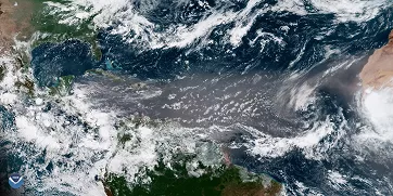
Saharan dust over the Atlantic, June 29, 2018; NOAA
In the northeastern Pacific, activity peaks between June and October. Tropical cyclones mainly form with the Intertropical Convergence Zone (ITCZ) and the monsoon trough, which often lie close to Central America’s coast.
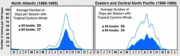
Seasonal cyclone activity: North Atlantic, Central and Eastern North Pacific; WMO
In the northern Indian Ocean, storm development is closely linked to the monsoon. During the peak of the southwest monsoon in July and August, there is a great deal of moisture over the ocean, but also strong vertical wind shear, which usually suppresses cyclogenesis. Tropical cyclones therefore form more often at the beginning of the season (May–June) and at the end (October–November), when the wind shear weakens.
The Northwestern Pacific has the world’s highest number of tropical cyclones, averaging 25–30 named storms yearly. With activity year-round, there is no official typhoon season. The quietest month is February, while the peak from August to October coincides with warm oceans and weak wind shear. Monsoon troughs and gyres foster conditions for multiple typhoons, and a smaller winter peak may occur at lower latitudes when the Madden–Julian Oscillation (MJO) enhances storm development.
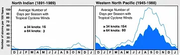
Seasonal cyclone activity: North Indian Ocean, Northwestern Pacific; WMO
In the ocean waters around Australia and the southern Indian Ocean, the main cyclone season falls between December and March, coinciding with the summer monsoon in the Southern Hemisphere. They most often form in the monsoon trough, whose position shifts during the season.
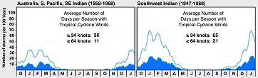
Seasonal cyclone activity: around Australia and the Southwest Indian Ocean; WMO
Tracking tropical cyclones with Windy.com
Even before a tropical cyclone forms, Windy.com lets you monitor key parameters such as sea surface temperature, humidity, and air flow at the surface and aloft, helping identify areas where storms may develop.
Once a cyclone forms, real-time satellite imagery and, where available, radar data are provided.
Hurricane Tracker: forecast path of Tropical Storm Mario; Windy.com
To forecast its strength and track, you can use the hurricane tracker, which uniquely compares forecasts from multiple models (ECMWF, GFS, ICON, etc.) and reveals uncertainties. Potential impacts can then be explored across forecast layers, from wind and gusts to rainfall totals. Official warnings from national meteorological services are also available, helping you prepare in advance for dangerous weather.
Windy.com brings all the tools for tracking tropical cyclones into one clear and visually distinctive platform.
Comments (3)